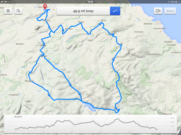
I thought I would try out an app on the iPhone/iPad to devise cycling routes. From somewhere Footpath appeared. I sometimes think that this sort of app is modern magic. Once the app kicks off, all you do is touch the draw button, then draw a vague line along a part of the route you want to take, the app then joins up the roads. You can also fill in the route manually for off road stuff. Clicking on the gradient box at the top shows the profiles and amount of climbing to look forward to(?) Clicking on the distance box changes the display from miles & feet to km & metres. All very simple, plus you can save the route to upload to your GPS or other mapping apps.
In my last blog I outlined some of the steep ascents round about and and Jean (https://cyclewriteblog.wordpress.com/) suggested that photographs would have enhanced the blog. So, the idea came to link them all and photograph them all as I went round. I have mapped the route, with just a tiny bit of climbing? And as I said before some folk think central Scotland is flat. So next time I have the inclination and the weather it will be time to pack some goodies and document a special ride. The link for the app is: https://footpathapp.com
And – here’s the proposed route


I installed the app and duplicated a few previous trips. Looks good! The elevation profiles are pure gold for cycling.
The Gaia GPS app for iPhone is another great traveling app. It has the capability to download maps and have true off-network GPS funtions.
LikeLike
This sounds like a fantastic piece of technology that will be great for your cycling and indirectly benefit the fans of your blog, like me! The route looks good, I feel tired out already!!!! Happy cycling 🙂
LikeLiked by 1 person
Thanks, looks like some pals might come along for the ride as well. The app has proved useful as in my geeky way I log my rides, times, climbing etc. But my Garmin has been playing up (missed 7+ miles yesterday) so Footpath has been helpful in sorting the truer values for my spreadsheet.
LikeLiked by 1 person
The technology is quite incredible really, I am constantly amazed!😀
LikeLiked by 1 person
And thanks for being a fan as well!
LikeLiked by 1 person
I am! 😀
LikeLike